NWS: Wednesday Rain Could Worsen Flooded Areas

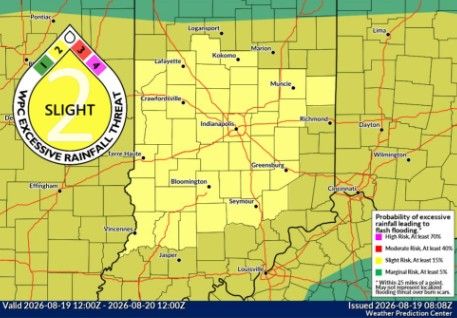
INDIANAPOLIS — National Weather Service Indianapolis forecaster Kacie Fucson says more rain on Wednesday across north-central Indiana could affect already flooded areas and push some rivers higher.
“Somewhere across north-central Indiana, we could see around an inch of rain, maybe locally higher amounts,” Fucson said. “That could definitely impact flooding along our rivers and potentially raise points along the rivers downstream into the Indianapolis area.”
Fucson says there is also a chance for isolated severe weather.
“There’s also a chance of some isolated severe weather, mainly damaging wind, potentially some hail in there as well,” she said.
With the ground already saturated across Indiana, Fucson says it won’t take much wind to cause additional problems.
“It’s not going to take much wind to snap things over,” she said.
The White River below flood stage is still in what the National Weather Service calls the action stage. Fucson says additional rain could cause river levels to rise again.
“Depending on the rain we get today, we could see those slowly go back into active,” she said.
Fucson says a river crest is the highest point the river is expected to reach before water levels begin falling. She says the timing and height of a crest depend on several factors, including conditions upstream.
“There could even be issues upstream that might impact how things flood further downstream,” she said. “The quarry in Carmel filling up, that was an example of the water went elsewhere on its way downstream.”
NWS: Wednesday Rain Could Worsen Flooded Areas was originally published on wibc.com